The University of Ibadan
Botanical Garden

Introduction:
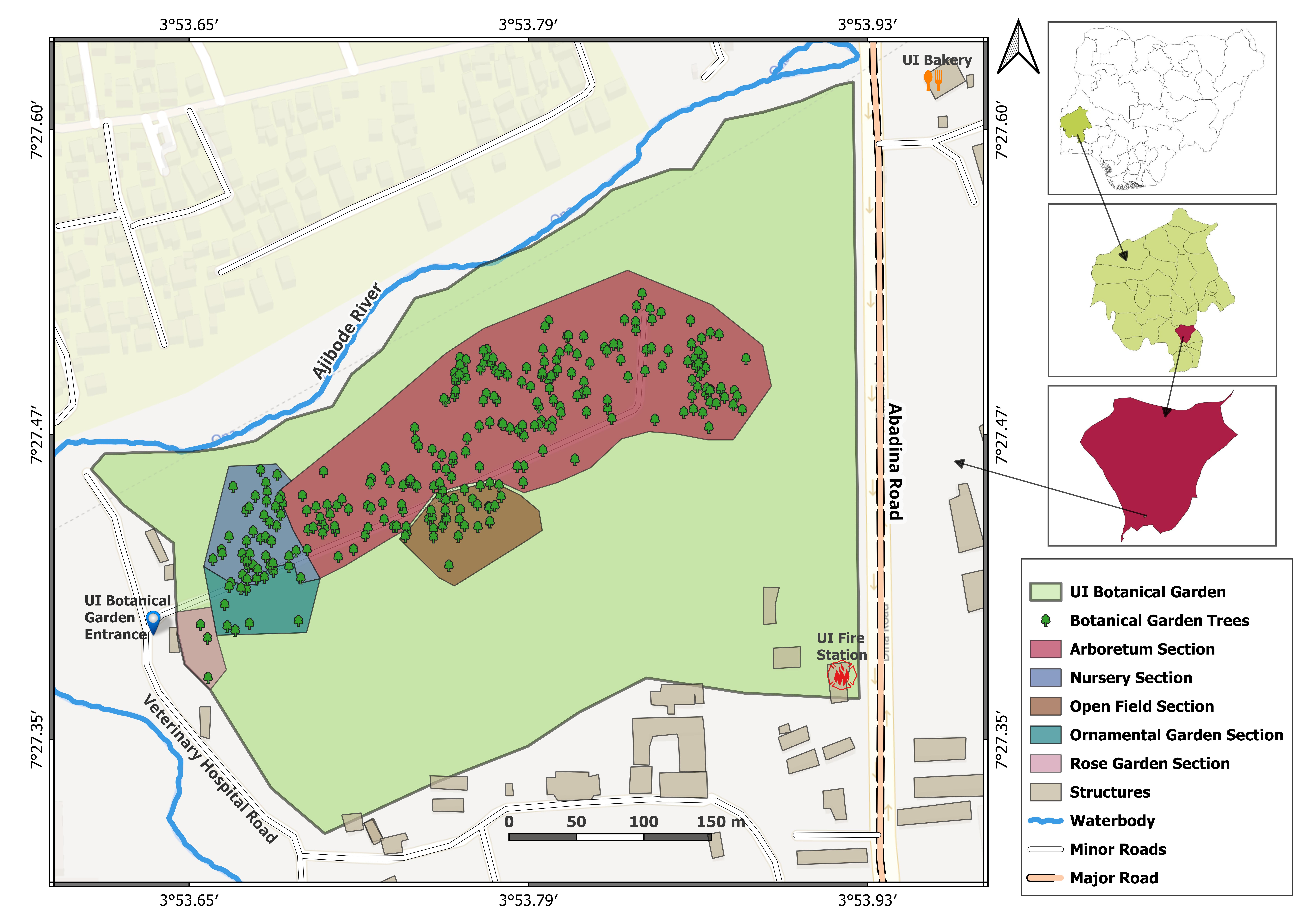
The University of Ibadan (UI) Botanical Garden is a significant green space designed for conservation, research, education, and recreation. It is an integral part of the university's landscape, contributing to biodiversity conservation and ecological sustainability. The garden is spatially structured into various sections that serve distinct botanical and ecological purposes.
Geospatial Characteristics:
The botanical garden is geographically situated within the University of Ibadan, Nigeria, as indicated by the location maps on the right-hand side of the image. The main entrance is positioned along Veterinary Teaching Hospital Road, while the garden is bounded by Abadina Road to the east and the Ajibode River to the north.
Spatial Zoning and Features:
The UI Botanical Garden is composed of five specialized zones, each serving unique ecological and horticultural purposes:
- Arboretum Section (Red Zone)
- The largest section of the garden, containing a diverse collection of woody tree species.
- Provides carbon sequestration potential and supports conservation of indigenous and exotic tree species.
- Facilitates long-term ecological monitoring and research in dendrology.
- Nursery Section (Blue Zone)
- A propagation area for growing young plants before transplanting into the garden.
- Supports research in plant breeding, conservation, and restoration ecology.
- Open Field Section (Brown Zone)
- Represents an open landscape area, possibly used for seasonal crops, grassland vegetation, or experimental plots.
- May serve as a site for ecological succession studies.
- Ornamental Garden Section (Green Zone)
- Designed for landscape aesthetics and biodiversity appreciation.
- Likely contains flowering plants, shrubs, and decorative plant species.
- Rose Garden Section (Pink Zone)
- Dedicated to rosaceous plant species, adding to the ornamental and aromatic value of the garden.
- Could support studies in pollination ecology and horticultural therapy.
Hydrological and Infrastructural Elements
- The Ajibode River, a natural waterbody, runs along the northern boundary, potentially influencing the garden’s microclimate and soil moisture content.
- The UI Fire Station, located along Abadina Road, suggests fire management considerations, which is crucial for preventing wildfires in dry seasons.
- The presence of minor and major roads within and around the garden ensures accessibility for visitors, researchers, and maintenance personnel.
- Nearby structures, including UI Bakery and other facilities, indicate an integration of the botanical garden within the university's socio-economic environment.
Ecological and Research Significance
The UI Botanical Garden is composed of five specialized zones, each serving unique ecological and horticultural purposes:
- Ecological and Research Significance
- The garden hosts a variety of tree species, providing habitat and refuge for wildlife, including birds and pollinators.
- Serves as a genetic bank for indigenous and exotic plant species.
- Carbon Sequestration and Climate Mitigation
- The tree cover density within the arboretum contributes to carbon storage, which is essential in mitigating climate change.
- The garden potentially plays a role in urban heat island effect reduction.
- Educational and Research Utility
- Supports academic research in botany, forestry, environmental sciences, and urban ecology.
- Aids in GIS-based spatial analysis, georeferencing of trees, and ecosystem services valuation.
- Recreational and Cultural Importance
- Provides an aesthetic and serene environment for leisure and tourism.
- May include walking trails, seating areas, and educational signage for public engagement.
Insights
Nursery Section
Open-field Section
Ornamental Section
Rose Garden Section
Arboretum Section
Health Data
Aboveground Biomass

Introduction:
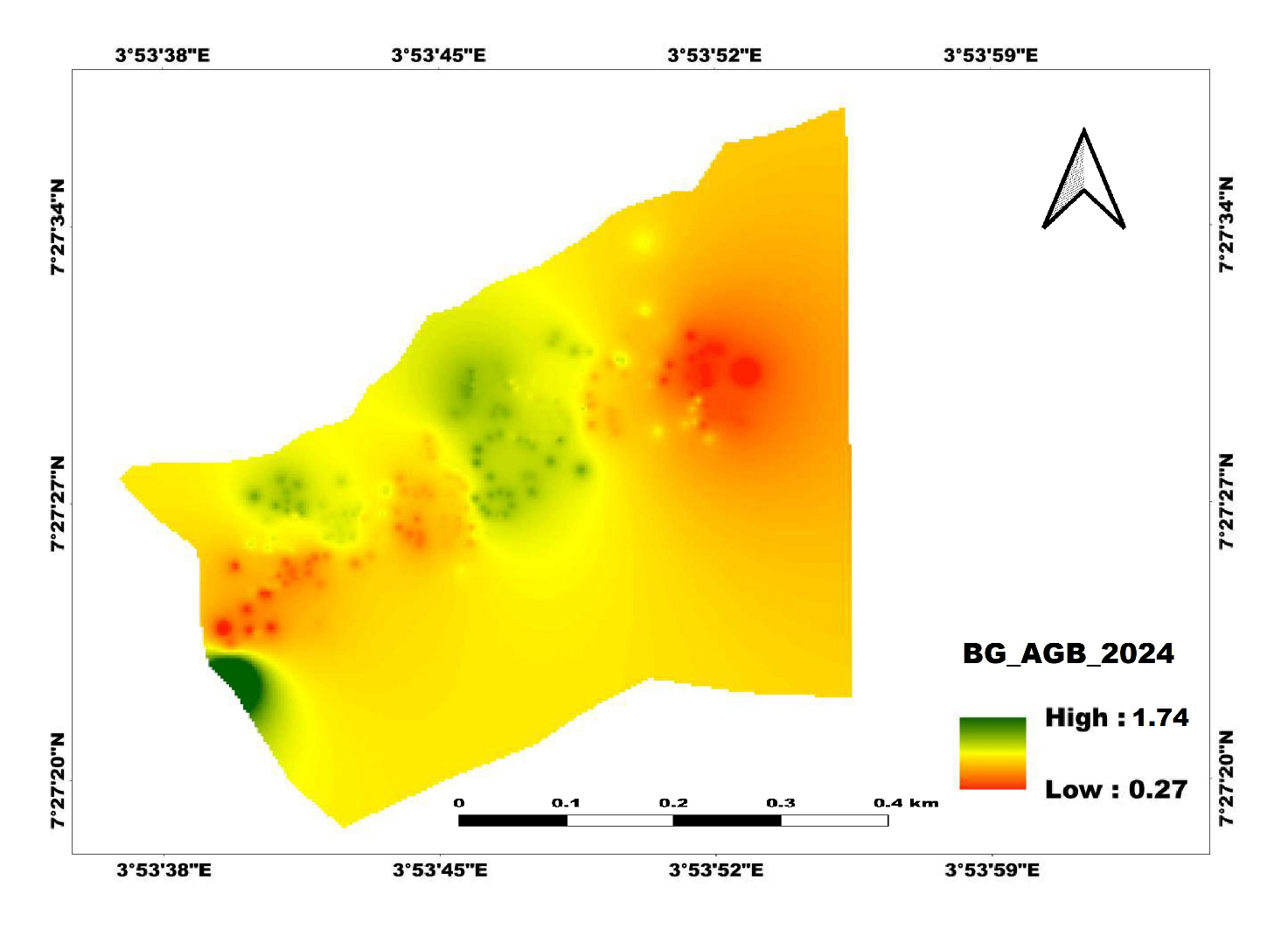
The Aboveground Biomass (AGB) Map provided is a spatial distribution map of biomass density in the University of Ibadan Botanical Garden (UIBG). This analysis is critical for understanding carbon storage potential, vegetation health, and ecological productivity. The map visualizes biomass levels using a color gradient ranging from low (0.27 mg/ha) to high (1.74mg/ha).
Spatial Distribution of Biomass
- Color Gradient Representation:
- Green areas indicate high biomass density (1.74mg/ha), signifying regions with mature trees, dense vegetation, or high carbon sequestration capacity.
- Yellow areas represent moderate biomass levels, suggesting regions with intermediate tree cover, younger vegetation, or lower canopy density.
- Red areas indicate low biomass density (0.27 mg/ha), which may correspond to open fields, sparsely vegetated areas, or degraded sections.
- Biomass Distribution Patterns:
- High Biomass Zones: Found mainly in the western and central portions, corresponding to arboretum section with dense tree cover.
- Moderate Biomass Zones: Scattered across the landscape, reflecting nursery and ornamental garden sections with a mix of trees and shrubs.
- Low Biomass Zones: Concentrated in the eastern and southeastern sections, corresponding to Open-field Section with sparse vegetation and grasslands.
Ecological and Environmental Implications
- Carbon Sequestration Potential:
- The high biomass areas contribute significantly to carbon storage, playing a role in climate change mitigation by absorbing atmospheric CO₂
- Identifying low biomass zones helps prioritize reforestation or enrichment planting to enhance carbon sequestration.
- Forest Health and Degradation Assessment:
- Areas with lower biomass densities may indicate degraded sections, deforested areas, or regions requiring active restoration.
- Monitoring biomass changes over time using remote sensing and GIS tools can aid in tracking ecosystem recovery and forest health..
- Land Management and Conservation Planning:
- The biomass gradient can guide conservation strategies, ensuring that high biomass areas are protected while degraded areas receive targeted interventions.
- Understanding biomass variation within the botanical garden can help in planning sustainable land-use practices, habitat restoration, and biodiversity conservation.
.jpg)
.jpg)
.jpg)
.jpg)
.jpg)